© Historic Charleston Foundation
Posted: October 4, 2018
What is the process if I want to elevate my house?
The process that a homeowner has to go through to raise their house varies depending on where in the City the home is. For all homeowners, your first stop should be the BAR/DRB counter at the Permit Center on the first floor of the Gaillard Center at 2 George Street. A receptionist at the entrance of the Permit Center can guide you to the right counter if you have trouble finding it. The BAR/DRB counter is staffed by City planning staff who can provide advice and guidance through every stage of applying to elevate your house. The first determination they will make is whether or not your home is within the jurisdiction of the BAR, as that dictates the submittal requirements for your application.
If your home is within the jurisdiction of the BAR, you will be required to submit a package of architectural drawings and will potentially have to appear before the BAR for a public hearing. Sometimes City staff feels comfortable approving applications at the staff level without a public hearing, but the elevation of buildings usually warrants a hearing. Meeting the BAR’s submittal requirements for architectural drawings is difficult for a layperson, and it is usually prudent to hire an architect to help. Visit BAR submittal requirements.
If your home is not within BAR jurisdiction, City staff will be able help you submit the appropriate documents for building permits depending on the scope and type of work that is proposed. Building elevations outside of BAR jurisdiction and the City’s historic neighborhoods are generally subject to less scrutiny than buildings within protected areas of the City.
Do I have to raise the house to meet FEMA requirements?
No! FEMA cannot compel you to raise your house, and you are under no obligation to conform to their standards.
What if my neighbor raises their house?
As of this writing, your neighbor raising their house has no effect on your property. However, one of the biggest challenges with raising historic homes is how to treat “sister houses”, or groupings of identical homes. At a recent building elevation workshop hosted by City planning staff, it was proposed that the first home to be elevated within a grouping of “sister houses” set an aesthetic template that the rest of the homes aspire to follow. The goal of such regulation would be to ensure that the homes within the grouping remain architecturally harmonious even after elevation, as opposed to each home using different elevation strategies and designs. This regulation has not yet been proposed, but is anticipated.
Where can I find the FEMA map?
Check out your City’s Flood Map (Current Version)
Check out your City’s Flood Map (Newer Draft Version)
Contact Stephen Julka in Zoning & Codes at the City of Charleston for specific questions about the impact of the flood map on individual properties: 843.720.1994 or [email protected].
Where can I find more information?
There are many links available to assist property owners assess flood risk and damage. HCF staff is also available as a resource for any technical needs.
Helpful Guide to Assessing Possible or Existing Flood Damage
City of Charleston Flood Ordinance and Freeboard Requirement
Terms to Know:
BAR: The Board of Architectural Review is a historic district design review board that is appointed by the Mayor and the Urban County Council. The Board of Architectural Review (BAR) holds twice monthly public hearings to review requests for exterior changes to properties protected within the historic district.
BFE: Base Flood Elevation. The computed elevation to which floodwater is anticipated to rise during the base flood. Base Flood Elevations (BFEs) are shown on Flood Insurance Rate Maps (FIRMs) and elevation certificates.
Elevation Certificate: An Elevation Certificate documents your building’s elevation. If you live in a high-risk flood zone, you should provide an Elevation Certificate to your insurance agent to obtain flood insurance and ensure that your premium accurately reflects your risk.
FEMA: The Federal Emergency Management Agency (FEMA) plays a critical role in meeting the needs of affected populations in the United States in the wake of a disaster. FEMA’s emergency support functions (ESFs) range from transportation and communications to logistics management and public safety and security.
FIRM/preFirm: Flood Insurance Rate Map (FIRM). For Charleston County, pre-FIRM includes all buildings in constructed prior to April 1, 1971. Post-FIRM buildings include new construction and buildings constructed after April 1, 1971. Insurance rates for Pre-FIRM and Post-FIRM buildings are dependent on the elevation of the lowest floor in relation to the Base Flood Elevation (BFE).
Flood Maps: Flood Maps published by the FEMA Map Service Center and is the official public source for flood hazard information in your area. The flood maps are currently being revised and it is anticipated that these new maps will be adopted in 2019 or 2020. Flood Vents: Flood Vents protect houses and buildings during floods by preventing hydrostatic pressure buildup that can destroy walls and foundations. This mitigation technique, referred to as Wet Flood proofing, allows floodwater to freely flow through an enclosure such as a crawlspace or garage.
Freeboard: An additional amount of height above the Base Flood Elevation used as a factor of safety (e.g., 2 feet above the Base Flood) in determining the level at which a structure’s lowest floor must be elevated or flood proofed to be in accordance with state or community floodplain management regulations.
ICC: Increased Cost of Compliance is one of several resources for flood insurance policyholders who need additional help rebuilding after a flood. It provides up to $30,000 to help cover the cost of mitigation measures that will reduce flood risk.
Insurance Zones: Special Flood Hazard Areas represent the area subject to inundation by 1-percent-annual chance flood. Structures located within the SFHA have a 26-percent chance of flooding during the life of a standard 30-year mortgage. Federal floodplain management regulations and mandatory flood insurance purchase requirements apply in these zones.
NFIP: The National Flood Insurance Program was created as a result of the passage of the National Flood Insurance Act of 1968. Congress enacted the NFIP primarily in response to the lack of availability of private insurance and continued increases in federal disaster assistance due to floods.
Substantial Improvements: Any reconstruction, rehabilitation, addition, or other improvement of a structure, the cost of which equals or exceeds 50 percent of the market value of the structure before the “start of construction” of the improvement.
Substantial Damage: Substantial damage applies to a structure in a Special Flood Hazard Area (SFHA) – or 1-percent-annual-chance floodplain – for which the total cost of repairs is 50 percent or more of the structure’s market value before the disaster occurred, regardless of the cause of damage. 1000 Year Flood: A statistical way of expressing the probability of something happening in any given year. A “1000 year” storm event has a one in one thousand percent chance of happening in any given year. In other words, a 1000 year flood has a 0.1% chance of happening in any given year.
1000 Year Flood: A statistical way of expressing the probability of something happening in any given year. A “1000 year” storm event has a one in one thousand percent chance of happening in any given year. In other words, a 1000 year flood has a 0.1% chance of happening in any given year.
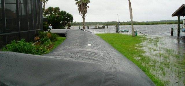
With inadequate stormwater infrastructure, King Tides and sea level rise, many Charleston-area property owners are seeking additional protection. Several flood damage mitigation strategies are available: Flood Barriers Perimeter barriers are…
Read More
Leave a Reply