© Historic Charleston Foundation
Twenty-one B&W photographs showing the aftermath of the tornadoes of September 29, 1938. Photographs are distributed and mounted on two pages of a photo album, and are captioned.
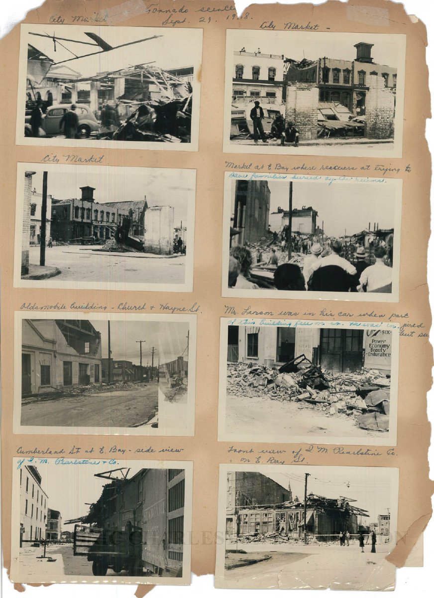
Page 1 (front), 8 photographs:
1: Captioned "City Market": View of building wreckage of buildings
2: Captioned "City Market" View 36-38 and 40-42 North Market
3: Captioned "City Market": View of Gulf Fruit Company (Claussen Range, 36-38 North Market) and a portion of the Old Church of the Redeemer (34 North Market)
4: Captioned "Market at East Baywhere rescuers are trying to save families buried by the ruins."
5: Captioned "Oldsmobile building, Church and Hayne Street." View of the Oldsmobile building [dealer] building at 12 Hayne and the adjacent building at 10 Hayne.
6: Captioned " "Mr. Larson was in his car when part of this building fell on it. He was injured but see...[rest cut off]." Shows the front of the Oldsmobile building at 12 Hayne Street.
7: Captioned "Cumberland Street at East Bay, "side view of I.M. Pearlstine & Co."
8: Captioned "Front view of I.M. Pearlstine Co. on E. Bay Bay Street." Located at 203 East Bay, shows a view of the wreckage of the building showing the loss of its upper stories.
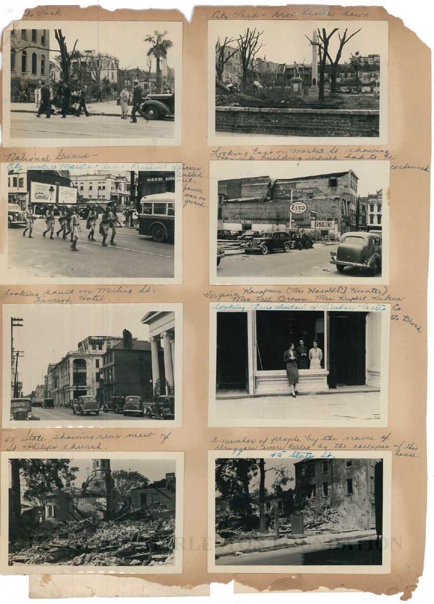
Page 1 (back), eight photographs:
1: Captioned "City Park." View of Washington Square Park from across the street. Also shows the edge of the east elevation of City Hall and the Fireproof Building.
2: Captioned "City Park, iron fence down": View of Washington Square Park showing the downed iron fence, statue of William Pitt (later moved to the County Courthouse), and the Washington Light Infantry obelisk. Surrounding buildings bordering the west and north sides of the park also in view.
3: Captioned "National Guard marching on Meeting Street. City under martial law. Reserve officers called out. James on guard." In background are the intersection of Meeting and Hasell Streets, 68 Hasell, and the Geer Drug Company (232 Meeting).
4: Captioned [incorrectly] "Looking east on Market Street showing Hornik building which had to be condemned." This actually is a view looking west on Hayne Street to Meeting Street, showing the north and east (rear) elevations of the four-story Hornik buildings that had been located at 194-196 Meeting Street. Also shows both the building directly to the rear (51 Hayne) and the site of an Esso station(~47-49 Hayne).
5: Captioned "Looking south on Meeting Street, Timrod Hotel." Shows the Timrod Hotel, the house at 103 Meeting, and the edge of the Hibernian Society.
6: Captioned "Virginia Kanapaux (Mrs. Harold[?] Hunter) [standing in front], Mrs. Nell Brown, Mrs. Rupert Kuhne looking through window of Pinckney Carter Company, 56 Broad."
7: Captioned" "45 State showing rear view of St. Philip's Church."
8: Captioned "45 State. A number of people by the name of Driggers were killed by the collapse of this house."
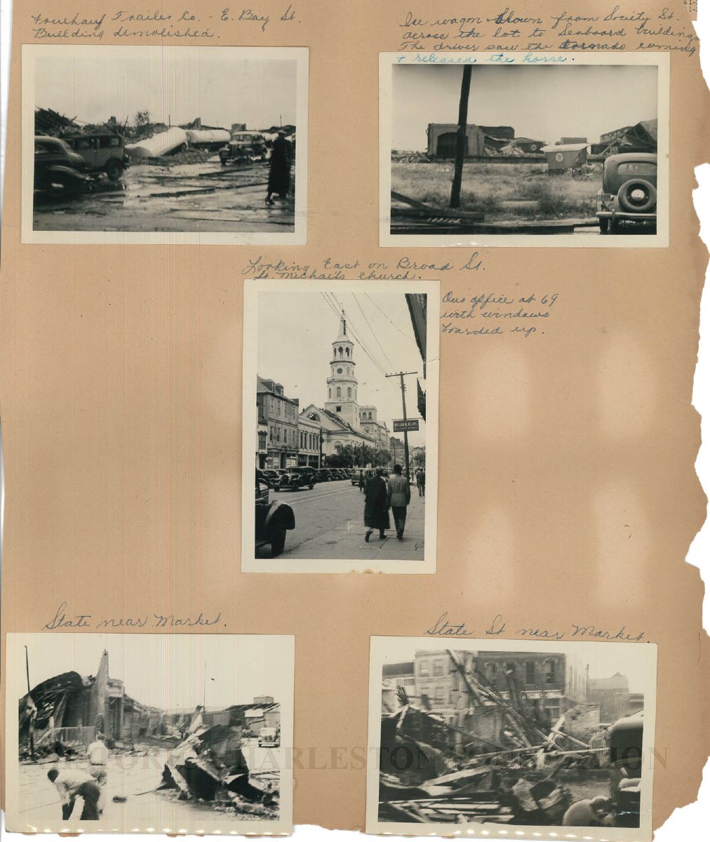
Page 2, five photographs:
1: Captioned Fouchauf[?] Trailer Co., East Bay Street. Building demolished."
2: Captioned "Ice wagon blown from Society Street across the lot to Seaboard Buildings. The driver saw the tornado coming and released the horse." The Seaboard Buildings were in the vicinity of 300 East Bay Street
3: Captioned "Looking [west] on Broad Street. St. Michael's Church. Our office at 69 Broad with windows boarded up."
4-5: Both captioned "State Street near Market." View of the wreckage.
Photographs of scenes at Fort Bragg, North Carolina on back of Page 2 (not shown in this record). Taken at Pope Field (later Pope Army Airfield), and could be from the late 1930s into 1941. The aircraft might be a Douglas A-20 Havoc, which, if so, would push the date to 1942.